
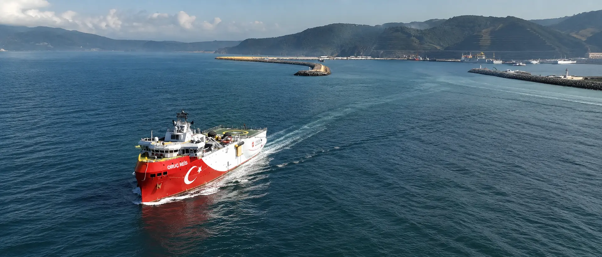
By Murat Yıldız
Türkiye's official navigational notice for Oruç Reis defines a limited offshore research block south of Anamur rather than the full route of the planned natural gas pipeline to the Turkish Republic of Northern Cyprus.
Notice 0731/26 authorises scientific research and underwater works by Oruç Reis and three support vessels between July 20 and August 30.
A Bosphorus News review of the four coordinates shows that the declared area covers approximately 386 square kilometres off Türkiye's southern coast. It remains well north of Cyprus and does not extend to Teknecik, the planned landing point for the pipeline.
Those reports presented the deployment as work along the full 101-kilometre route. Notice 0731/26 instead defines a compact survey block off Anamur, leaving most of the planned corridor outside the declared area.
Survey Block Covers Limited Area off Anamur
The four coordinates form an irregular offshore quadrilateral measuring roughly 30 kilometres at its widest point.
Its individual sides measure approximately 14.0, 24.6, 16.6 and 25.8 kilometres. The southern edge of the declared block remains around 70 to 75 kilometres from Teknecik on the northern coast of Cyprus.
A Bosphorus News map based on notice 0731/26 plots the four boundary points and shows the difference between the declared survey block and the full Anamur-Teknecik corridor. The block lies off Anamur, while most of the planned 101-kilometre corridor remains outside the current notice.
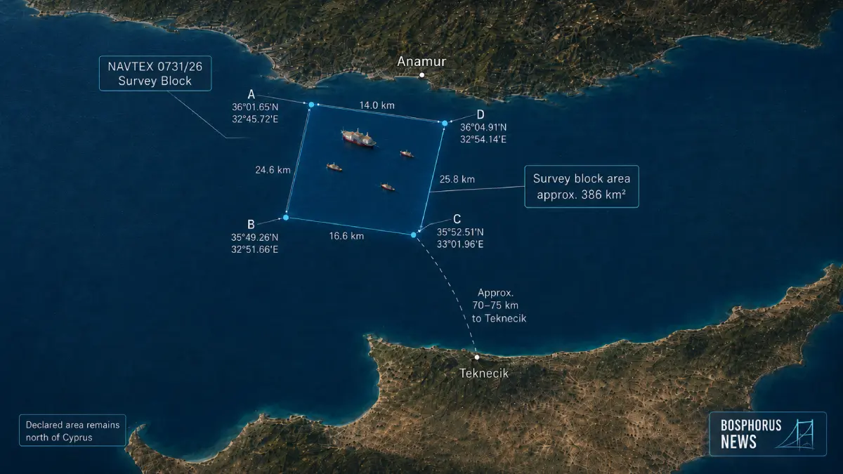
Map based on Türkiye's navigational notice 0731/26. The declared survey block covers approximately 386 square kilometres south of Anamur and remains around 70 to 75 kilometres from Teknecik. Graphic: Bosphorus News
The notice therefore does not cover the full route between Anamur and Teknecik.
It also does not identify the operation as a natural gas pipeline survey or explicitly describe the work as seismic. Its wording is limited to "scientific research and underwater works."
Oruç Reis will operate alongside Denar Explorer, Denar Pathfinder and Denar Surveyor. Other vessels have been instructed to keep clear of the research group.
The notice will remain in force until August 30 at 20:59 UTC.
Oruç Reis arrived off Taşucu on July 19 for preparations ahead of the deployment.
MarineTraffic Position Matches Declared Area
A MarineTraffic position check reviewed by Bosphorus News showed Oruç Reis operating south of Anamur, in the same northern offshore area defined by notice 0731/26.
The vessel was shown travelling at six knots on a heading of 247 degrees. Its reported position remained well north of Cyprus and was consistent with an operation concentrated near the Turkish end of the proposed pipeline corridor.
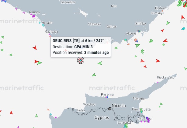
MarineTraffic screenshot reviewed by Bosphorus News shows Oruç Reis south of Anamur, in the northern offshore area covered by notice 0731/26.
The vessel position provides additional operational evidence that the deployment remains concentrated within the limited area identified by the NAVTEX coordinates, rather than extending across the full route to Teknecik.
Possible Link to Pipeline Preparations
The timing and location of the operation support a possible connection with preliminary engineering and seabed studies for the planned Türkiye-TRNC natural gas pipeline.
Energy and Natural Resources Minister Alparslan Bayraktar previously said the proposed line would run approximately 101 kilometres between Anamur and Teknecik.
The project envisages around 97 kilometres of offshore pipeline and four kilometres of onshore infrastructure. Türkiye and the TRNC have also described the system as bidirectional, initially carrying gas from Türkiye to the island while retaining the possibility of future flows in the opposite direction.
The survey block lies near the Turkish end of the planned corridor and may be connected to preparatory work around the mainland departure area. The navigational notice, however, does not identify the pipeline as the purpose of the operation.
No separate navigational notice covering the remaining section towards Cyprus was identified among the notices reviewed for the same period.
Full Route Survey Not Confirmed
The official notice confirms a marine research operation south of Anamur involving Oruç Reis and three accompanying vessels, but it does not establish that work has begun across the full 101-kilometre route to Teknecik.
Further navigational notices would be required if the survey advances southwards through separately declared phases. Turkish or Turkish Cypriot authorities may also clarify whether the deployment forms part of the pipeline's engineering programme.
Based on the NAVTEX coordinates and the vessel position reviewed by Bosphorus News, the current operation covers a compact offshore block near Anamur, not the full Türkiye-TRNC pipeline route.
Sources: Türkiye navigational notice 0731/26, Türkiye's Ministry of Energy and Natural Resources, MarineTraffic, TRNC official statements, Bosphorus News review and reporting.