
By Bosphorus News Geopolitics Desk
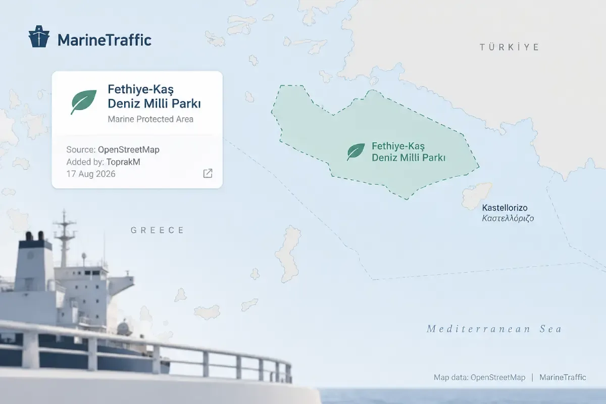
A Turkish presidential decision became an OpenStreetMap object within two days and later surfaced on MarineTraffic without the platform assigning the name. The label appeared south of the Greek island of Kastellorizo, in waters already at the center of a dispute between Greece and Türkiye.
Greek websites reported on Sept. 1 and 2 that MarineTraffic, the ship-tracking platform used across the maritime industry, had renamed the sea area after the marine park Türkiye declared in August. The reports followed an X post carrying a screenshot of the platform. Pronews described the display as a renaming, and several other Greek sites repeated the claim.
The label was there. It had reached the platform through a different route.
Greece Fact Check traced it to OpenStreetMap, the collaborative geographic database credited in MarineTraffic's map attribution. Its investigation found that an account using the handle ToprakM added "Fethiye-Kaş Deniz Milli Parkı" on Aug. 17, 2026, citing Türkiye's Official Gazette as the source.
The edit did not rename an existing maritime area. It created a new protected-area object in OpenStreetMap, which later appeared through mapping data used by MarineTraffic.
Greece Fact Check also contacted MarineTraffic. In a Sept. 2 response, a spokesperson said geographic names displayed on the service form part of a basemap supplied by an external map data provider and are not determined or assigned by Kpler, MarineTraffic's parent company.
What Türkiye Declared
Presidential Decisions No. 11626 and 11627, dated Aug. 15, established the Fethiye-Kaş and North Aegean marine national parks. They were published the following day in Official Gazette No. 33342 under Türkiye's National Parks Law.
The Fethiye-Kaş park covers 2,170,603 hectares, roughly 21,706 square kilometres, according to Türkiye's Directorate General for Nature Conservation and National Parks. Its limits are defined by an annexed map and coordinate list.
Those coordinates take the park into waters around Kastellorizo. Greece's Foreign Ministry said on Aug. 16 that the two Turkish parks extend beyond Turkish territorial waters, including into areas Athens considers part of the Greek continental shelf, and argued that the designations have no legal effect there.
Türkiye had objected when Greece announced its own marine parks in July 2025 and said it would proceed with environmental protection projects in areas it considers under its jurisdiction.
The disagreement entered formal diplomacy on Sept. 3. Athens included the parks and three Greek spatial-planning frameworks in a protest démarche delivered in Ankara, where Turkish officials handed over their own notes verbales during the same exchange.
From a State Record to a Commercial Map
OpenStreetMap is built through user contributions rather than by a government or international cartographic authority. Its edits are public and can be reviewed, changed or reverted by contributors.
The OpenStreetMap Foundation also states that the appearance of a name or boundary in its database does not establish that information as legally correct in any jurisdiction.
The contributor who added Fethiye-Kaş cited an authentic Turkish government document. That identifies the source of the edit. It does not settle the legal status of the park boundary in contested waters, and it does not amount to endorsement by OpenStreetMap, MarineTraffic or Kpler.
Greece Fact Check concluded that MarineTraffic had neither renamed the maritime area nor independently assigned the Turkish park name. The label had entered the platform through a separate, user-edited mapping system.
Kathimerini reported on Sept. 2 that Athens was expected to raise the display with the platform. No public statement from the Greek Foreign Ministry or Kpler confirming such an approach had been identified at the time of publication.
The MarineTraffic display changes nothing in the underlying jurisdictional dispute. Greece's objection remains directed at Türkiye's park decree and the waters covered by it, not at the legal status of an OpenStreetMap label.
What the episode does show is how quickly an official designation can move beyond the document that created it.
Greece and Türkiye have increasingly placed competing Aegean and Eastern Mediterranean positions into planning maps, park decrees and diplomatic records. Türkiye's Marine Spatial Planning Map was announced in April 2025 and notified to the United Nations Educational, Scientific and Cultural Organization's Intergovernmental Oceanographic Commission on June 12.
The Kastellorizo episode moved faster. Türkiye published the park decision on Aug. 16. A user entered the protected area into OpenStreetMap on Aug. 17. It later appeared on MarineTraffic without a separate naming decision by the platform.
One contributor, one day after publication, with a citation to the Official Gazette.
The same jurisdictional dispute is also active through navigational notices this month. Türkiye's NAVTEX 0862/26 announced scientific work by the R/V TÜBİTAK MARMARA at four positions between Sept. 1 and 15. Greece's responding NAVWARN 1036/26 challenged one of those positions as lying over what Athens considers its continental shelf and within the Heraklion NAVTEX service area. Both notices expire on Sept. 15.
The OpenStreetMap object has no comparable expiry date. It remains subject instead to the database's own public editing and review process.
Sources: Turkish Official Gazette No. 33342, Hellenic Republic Ministry of Foreign Affairs, Republic of Türkiye Ministry of Foreign Affairs, OpenStreetMap and OpenStreetMap Foundation, Kpler response to Greece Fact Check, Greece Fact Check, Kathimerini, Bosphorus News review and reporting.